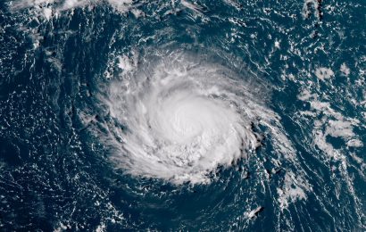
While a big part of the US is still focusing on the destruction that Harvey has made, hurricane Irma is quickly gaining power in the open Atlantic, posing a major threat to the Caribbean and the US next week
Irma was categorized as a tropical storm on Wednesday morning, and by Thursday it had strengthened into a Category 3 hurricane, with winds of 115 mph.
Such strengthening is known as “rapid intensification”, and means that its wind speed increased at least 30 knots (35 mph) in 24 hours.
“Irma has become an impressive hurricane,” the National Hurricane Center said on Thursday, noting the rapid intensification, and saying “this is a remarkable 50 knot [58 mph] increase from yesterday at this time.”
Hurricane Harvey had a similar story. It underwent rapid intensification last week, before landfall, which brought it from a tropical storm to a Category 4 hurricane.
However, Irma is a classic “Cape Verde hurricane,” which means that it forms in the far eastern Atlantic, near the Cape Verde Islands (currently known as the Cabo Verde Islands) and tracks across the Atlantic. Cape Verde storms are among the most intense and largest hurricanes. Examples include: Hurricane Hugo, Floyd, and Ivan.
Irma is forecast to keep gaining strength as it moves westward in the following five days, while the official forecast from the National Hurricane Center puts a dangerous Category 4 tag on it.
A strong ridge to the north of Irma, over the Atlantic, is directing the storm to the west and limiting the wind shear in the upper levels of the atmosphere; this allowed the storm to grow fast. Unfortunately, Irma will stay in a low-shear environment for the next several days, which means that it won’t weaken soon.
Source: cnn.com


