NASA put together data from different sources to create a glowing map that depicts the areas where dust clouds swirl across Earth
There’s nothing new to the fact that we wander from one cloud of dust to the next and that the air is full of black carbon soot from wildfires, salt wafting from the sea and dusty emissions from our heavy industry.
Usually, this sort of dust is invisible to us, but not to NASA’s satellites and ground sensors, of course. In an amazing new illustration, NASA’s Earth Observatory revealed the invisible, small particles that float around us.
To create this image, NASA combined data from numerous sensors on satellites such as the Moderate Resolution Imaging Spectroradiometer (MODIS) sensors on Aqua and Terra, as well as ground based sensors.
Interesting is the fact that some dust clouds are the result of weather events such as the hurricane Lane near Hawaii and typhoons Soulik and Cimaron.
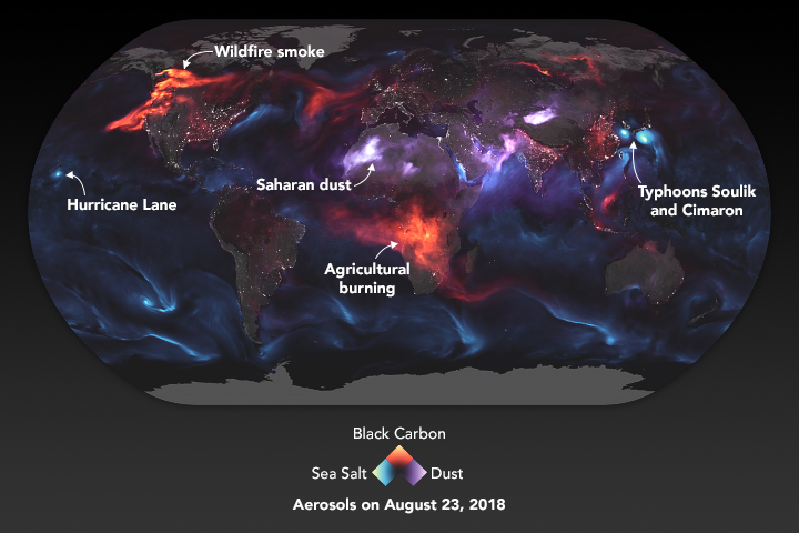
Western North America and south-central Africa show us signatures of some other sort of aerosol: the smoke from wildfires, which are often set by humans, intentionally or as part of annual agricultural cycles in Africa. Some of the smoke from North America looks to have drifted east over the Atlantic Ocean.
NASA explained that the image was not shot by a single camera and that it’s not even a composite of numerous images directly taken by satellites or ground sensors. Instead, NASA used careful mathematics to bring together the data from various sources in order to figure out the densest concentrations of loose particles in the atmosphere.
Source: foxnews.com


